
Car Navigation in a Pre-GPS era
- MG
- May 30, 2018
- 4 min read
These days, GPS navigation is an essential accessory in every vehicle, and you’ll be hard pressed to find someone who still uses a street directory (remember those?). Even if you don’t have a GPS navigation system built into your car or have an aftermarket GPS navigation device you still have your phone with access to Google Maps, or Apple Maps which can be used for GPS navigation.
However, the concept of a screen-based navigation system in a car may be much older than you think. The origins of vehicle navigation systems can be traced back to over 35 years ago and quite possibly stretch to the early days of motoring itself.

Quite possibly the first ever vehicle navigation device, the Jones Live Map consisted of a circular piece of paper with instructions printed on. This was placed on a glass-enclosed mechanical turntable which was connected to the car’s odometer. As the car kept driving, the piece of paper would turn, and the instructions corresponding to the odometer reading would become right-side-up. Each disc covered up to a hundred miles of road and by 1919, over 500 routes were published covering most of the United States.

(Via 99%visible.com)
These devices are lumped together as they worked on the same principle: scrolling road maps. The Plus Four Wristlet Route Indicator was a small device that attached to the driver’s wrist and used small paper maps that had to be manually scrolled. While a nifty little device, it was impractical as when drivers turned onto a different road, they had to swap out the map to the corresponding road. But, it’s better than getting lost, I guess. The Wristlet was never mass produced and its price at the time was 5 pounds. Supposedly, it also had a secondary function of keeping golf scores.

At least the Iter Avto looks like an archaic GPS navigation device. Much like the Plus Four Wristlet, the Iter Avto used scrolling paper maps. Very little is known about the Iter Avto or the company that made it. However, form what could be gathered, the device was attached to the speedometer, meaning that the scroll rate depended on the car’s speed. But, again, the maps had to be swapped out when turning onto another street.
Lauded as the first ever electronic map-based navigation system, Honda’s elaborate Electro Gyrocator looks like it came straight off the set of Blade Runner (1982). Developed 14 years prior to GPS going public, the Gyrocator used a mileage tracker on the car’s non-driving wheels and a helium-jet gyroscope, both of which had to be built into the car. The heads-up display consisted of a 15-centimetre green cathode-ray screen and the car was represented by a white dot. Since the device’s internal computer could not store any map data, the Gyrocator used interchangeable transparent road maps which overlayed the screen. Once the driver reached the edge of a map, they had to adjust the screen and replace the map overlay.
Honda sold the Gyrocator as an option with the Honda Accord and Honda Vigor. However, with a ¥300,000 price tag, the device costed a quarter of the amount as the car it was installed in.
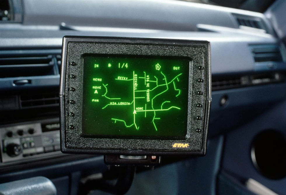
In the US, the first commercially available navigation system was the Etak Navigator, which was developed by American engineer Stan Honey and bank-rolled by Nolan Bushnell, co-founder of Atari and Chuck E. Cheese. The Etak Navigator used an electronic compass attached to the car’s rear windshield and sensors attached to the car’s non-driven wheels, which measured the car’s speed, distance travelled and turn direction. The Navigator’s display was made up of a vector-based CRT display that could only display straight lines but provided a high enough resolution for the time. The screen came in two sizes: 4.5 inches (approx. 11.5 cm) and 7 inches (approx. 17.8 cm) and the map data was stored on specially made cassette tapes that could withstand the hot California sun. Because no GPS satellites were available, the maps had to be created by Etak’s digital cartographers called “digitizers”. Also, worth noting is Etak pioneered the driver-centric view point and much of the map data gather by Etak is still in use today.
At the time, the Etak Navigator was the only after-market electronic navigation device available commercially. The 400 model (4.5-inch display) sold for US$1,395 and the 700 model (7-inch display) $1,595 with each map cassette costing $35. Initially, only the San Francisco bay area was available and Etak would eventually release newer maps.
Then in 1995 the GPS was made publicly available, rendering these devices obsolete. Of course, the first GPS navigation devices weren’t that much cheaper than their predecessors and weren’t as reliable to what we’re used to today. Nowadays, we take GPS navigation for granted without considering the decades of research and development that went into making them. However, the pre-GPS era yielded some fascinating developments that contributed to the making of the GPS navigation system we know today.


Exploring how drivers navigated before GPS really highlights how far automotive tech has come. Alongside navigation, advancements in diagnostics and component servicing have also evolved. Providers like bcs automotive offer cutting-edge solutions that keep modern vehicles running smoothly—ensuring today’s journeys are not only easier to navigate but also safer and more efficient.
HOW TO FIND A LEGITIMATE CRYPTO RECOVERY EXPERT. HIRE FASTFUND RECOVERY.
I never thought I'd see my lost crypto again after falling victim to a phishing scam that wiped out my wallet. I contacted FastFund Recovery out of desperation, and to my surprise, they were professional, responsive, and thorough. Within a few weeks, they were able to trace the stolen assets and recover a significant portion of my funds. Their constant updates and transparency throughout the process gave me peace of mind. I’m incredibly grateful for their help. FastFund Recovery truly delivered when I needed it most.
G-mail: Fastfundrecovery8@gmail com. Whatsapp: 1807 500 7554
Discovering hidden messages from a cheating spouse can be incredibly challenging. If you’re looking to keep track of phone activity discreetly, infotheprohackers@gmail.com offers an online utility that monitors texts, calls, and social media. You can try it out risk-free and get the clarity you need without added stress.